 Facebook
 Twitter
 Pinterest
 Copy Link
Waterfront Defined

Terminology
These local definitions will not only to help you know the lingo when it comes to waterfront speak, but to give you quick access tools to research waterfront to your heart’s content. Here is a quick resource to commonly used terms related to waterfront real property:
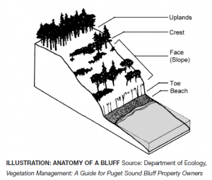
Bluff Most beaches on Puget Sound are backed by bluffs. These bluffs can vary from spectacular, high eroding cliffs to low, vegetated banks. The erosion of bluffs is a significant source of sediment on many Puget Sound beaches. One way of classifying bluffs is by the amount of sediment they provide to local beaches as they erode. This is based on how fast they erode, how high they are, and how much sand and gravel they contain. In these maps, bluffs are assigned to the following categories: Exceptional Feeder Bluffs; Feeder Bluffs; Feeder Bluff – talus; and Transport Zones. This Department of Ecology Feeder Bluffs and Coastal Landforms Map is a great tool for identifying bluff categories.
Boathouse A building designed for the storage of boats or watercraft to provide protection from the elements. The building of boathouses is generally prohibited under current environment regulations, but many grandfathered boathouses remain throughout the region.
Bulkhead A solid or open pile wall of rock, concrete, steel or timber or other materials or a combination of these materials erected generally parallel to and near the ordinary high water mark for the purpose of protecting adjacent wetlands and uplands from waves or currents.
Dock A raised walkway over water, often supported by widely spread pilings or pillars. Recent dock requirements encourage the use of decking structures and systems that encourage light and air flow to the water below. Also referred to as a pier.
Dock inspection A structural and functional evaluation by an individual or company who specializes in dock construction and repair. This can involve an underwater dive evaluation when portions of the supporting structure is in question or unobservable from above.
High bank waterfront Land that sits substantially above the natural water line, making the waterfront inaccessible without stairs or other structures, if at all.
Low bank waterfront Land that sits just above the natural water line, often delineated with a bulkhead protecting the shoreline. Low and no bank waterfront abutting a navigable lake is often considered the most desirable waterfront in the Puget Sound region.
Medium bank waterfront The most subjective of terms, this represents moderate bank land that is lower than high bank and higher than low bank waterfront.
Moorage A place where a boat or ship are secured in the water. As it pertains to waterfront real estate, this is typically on a privately owned dock or boathouse.
Navigable water “Navigability or navigable” means that a body of water is capable or susceptible of having been or being used for the transport of useful commerce. The state of Washington considers all bodies of water meandered by government surveyors as navigable unless otherwise declared by a court. See Who Owns the Water?
No bank waterfront Land that graduates out to the natural water line without a bulkhead separating it from the shoreline. Often described as rolling waterfront, its spacious feel at lakeside is highly desirable.
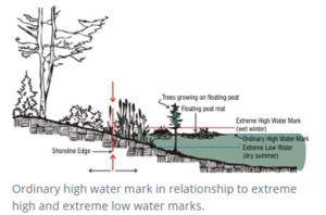
Ordinary High Water “Ordinary high water” means, for the purpose of asserting state ownership, the line of permanent upland vegetation along the shores of nontidal navigable waters. In the absence of vegetation, it is the line of mean high water.
Pier A raised walkway over water, often supported by widely spread pilings or pillars. Recent dock requirements encourage the use of decking structures and systems that encourage light and air flow to the water below. Also referred to as a dock.
Private Waterfront Land abutting the water owned exclusively by an individual land parcel. Greater waterfront footage and amenities (beach/dock/moorage) create a more valuable parcel than one with limited waterfront footage or amenities.
Shared Waterfront Land abutting the water owned in common (deeded) by owners of other often adjoining, land parcels. Fewer owner shares and deeded amenities (dock access/moorage) create a more valuable shared waterfront parcel than one with many owners or fewer amenities.
Shorelands Land which is alternately covered and left dry by the rising and falling of the water level of a lake, river, or tidal area.
“First class shorelands” means the shores of a navigable lake or river belonging to the state not subject to tidal flow, lying between the line of ordinary high water and the line of navigability, or the inner harbor line where established and within or in front of the corporate limits of any city, or within two miles thereof upon either side (RCW 79.105.060(3)). These boundary descriptions represent the general rule; however exceptions do exist. To determine if the shorelands are within two miles of the corporate limits of a city, the distance is measured along the shoreline from the intersection of the corporate limit with the shoreline.
“Second class shorelands” means the shores of a navigable lake or river belonging to the state, not subject to tidal flow, lying between the line of ordinary high water and the line of navigability, and more than two miles from the corporate limits of any city (RCW 79.105.060(17)). These boundary definitions represent the general rule; however, exceptions do exist. To determine if shorelands are more than two miles from the corporate limits of a city, the distance is measured along the shoreline from the intersection of the corporate limit with the shoreline.
(Public) Tidelands Land belonging to and held in public trust by the state for the citizens of the state, which are not devoted to or reserved for a particular use by law. Typically, the portion of land below the ordinary high water mark and the navigable water. Tide lines have been an area of great controversy in Washington State. Considered public domain through the Public Trust Doctrine. The Public Trust Doctrine does not allow the public to trespass over privately-owned uplands to access the tidelands. It does, however, protect public use of navigable water bodies below the ordinary high water mark.
“First class tidelands” means the shores of navigable tidal waters belonging to the state lying within or in front of the corporate limits of any city, or within one mile thereof upon either side and between the line of ordinary high tide and the inner harbor line; and within two miles of the corporate limits on either side and between the line of ordinary high tide and the line of extreme low tide (RCW 79.105.060(4)). In general, the line of ordinary high tide is the landward boundary. The line of extreme low tide, or the inner harbor line where established, is the waterward boundary. To determine if the tidelands are within two miles of the corporate limits of a city, the distance is measured along the shoreline from the intersection of the corporate limit with the shoreline.
“Second class tidelands” means the shores of navigable tidal waters belonging to the state, lying outside of and more than two miles from the corporate limits of any city and between the line of ordinary high tide and the line of extreme low tide (RCW 79.105.060(18)). In general, the line of ordinary high tide is the landward boundary. The line of extreme low tide is the waterward boundary. To determine if the tidelands are more than two miles from the corporate limits of a city, the distance is measured along the shoreline from the intersection of the corporate limit with the shoreline. Excerpt from the Department of Ecology Public Trust Doctrine.
Waterfront Footage The linear feet that span the water’s edge of a land parcel.
Watershed A watershed is the land area draining to a nearby river or lake, or sound.
Maps
There are many local map portals to assist in identifying topography, water conditions, hazards, and critical areas.
iMap Parcel Lookup Instructions (PDF)
Washington DNR Natural Hazards Geological Maps
Washington Geographic Information Portal Map
Department of Ecology Feeder Bluffs and Coastal Landforms Map
Department of Ecology Wetlands Inventory Map
NOAA Puget Sound Water Depth Chart
Resources
King County
King County currently has about 1200 documented residential docks and 58 private boat ramps (see shoreline land use facts). A permit is required to build, modify, alter the land abutting a shoreline.
King County Shoreline Management Fact Sheets and Links
King County Shoreline Permit Submittal Requirements (PDF)
King County Bulkhead Shoreline Requirements (PDF)
Shoreline Site Plan Requirements (PDF)
King County Shoreline Property Owner Resources
King County Lake Services and Information
Puget Sound Shoreline Stewardship Guidebook
King County Water and Shorelines Glossary
Washington State
Washington State (RCW) Aquatic Land legal definitions
DFW – Your Marine Waterfront (PDF)
DNR – Puget Sound and Coastal Geology
DNR – Puget Lowland Geological Province
Dept of Ecology – Mapping Bluffs and Beaches of Puget Sound (PDF)
WSU Guide for Shoreline Living (PDF)
UW Puget Sound Fact Book (PDF)
Environmental Protection Agency
Shoreline and Wetland Tools and Resources
King County watershed overview map
Cedar River – Lake Washington Watershed (Lake Washington waterfront properties)
Central Puget Sound Watershed (North/West Seattle waterfront on Puget Sound)
Green-Duwamish River Watershed (South Seattle waterfront properties on Puget Sound)
Sammamish Watershed (Lake Sammamish waterfront properties)
National Oceanic and Atmospheric Administration
ERMA visualization map of Puget Sound
Bluffs, landforms and habitat classifications
The Watershed Company (site evaluation contractor) Articles
A home buyer’s guide to property with critical areas
Shoreline planning and permitting
We hope this provides an outstanding starting point in your waterfront journey. In addition to this specific research, don’t forget to evaluate all the typical aspects of your potential new home and neighborhood. We’ve compiled links to research tools from schools and geological hazards to market reports and census data.
While you’re there, you can also look up neighborhood info, including crime reporting, local government resources, parks and recreation, and school boundaries.
Of course, nothing tops having an experienced broker to guide you through the process. They’ve seen hundreds upon hundreds of homes and can help you identify the solid finds from the duds with gorgeous looking veneer.
Choosing the right broker can save you thousands on your home purchase. Whether through local market knowledge and pricing analysis allowing you to make a smarter offer, recommendations and resources to thoroughly conduct your due diligence and avoid costly mistakes, or savvy contract negotiation to help you get the terms you need, having a Windermere broker on your side is one advantage you can’t afford to sacrifice.
Find a Home | Sell Your Home | Property Research | Neighborhoods | Market Reports | Our Team
We earn the trust and loyalty of our brokers and clients by doing real estate exceptionally well. The leader in our market, we deliver client-focused service in an authentic, collaborative and transparent manner and with the unmatched knowledge and expertise that comes from decades of experience.
© Copyright 2020 Windermere Mercer Island.
Evaluating Waterfront Property Values

While supply and demand clearly play a role in establishing the value of a waterfront property, several unique elements overshadow the typical supply divided by demand equation.
The first one is rarity. Examples of this include:
- point properties—waterfront at the tip of one of our few natural points—with more expansive water frontage and street privacy
- parcels with extended front footage—homes that have far more waterfront feet than the norm (i.e. 180 front feet versus a more typical 60-80 feet)
- iconic properties—homes that have significant owners or histories
As with all real estate, location is a critical factor in assessing waterfront value. Any given property will have a value adjustment based on where it sits on the map and how the surrounding properties influence it. You can’t establish value without first determining the range of values for that location. When there are few comparable recent sales in a given location we often separate land value from the house value, compare them separately to other sold properties and then determine their combined value.
Waterfront access and amenities, which affect how you can use the waterfront, are an important consideration. This includes topography, dock, water depth and exclusivity. Higher value is generally given to:
- no or low bank waterfront with walk out access
- expansive views unhindered by natural obstacles or man-made structures
- large dock structures in good condition and/or boat houses that can no longer be built
- locations with higher water quality and/or deep-water moorage/access
A waterfront home’s setting also plays an essential role in its value. Homes most in demand include those with:
- an estate-like feel and additional privacy
- comfortable road access and parking
- sunny exposure
- larger (useable) lot square footage
- preferential positioning of the home and windows to capture views from most rooms
- remodel/rebuild-slated homes that have good construction access
Last, but not least, is the structure itself. While many waterfront buyers chose to make substantial changes to put their signature on their home, many still prefer turnkey homes with desirable floor plans and amenities. Because desired amenities change over time and the typical owner/buyer can usually afford to create what they want, waterfront homes tend to see the wrecking ball far earlier than non-waterfront properties.
In summing it all up, waterfront value is affected by many different criteria with supply and demand often determining how quickly a home will transact. The fewer potential buyers for a given price point, the longer the market time will typically be. That said, many waterfront buyers spend years waiting for the right combination of personally-desired features and amenities to come to market—making the demand less predictable than in other real estate arenas. This explains why you might see an expensive, rare waterfront property transact very quickly while similar homes sit on the market for years. Another old saying might sum up waterfront value best, “Beauty (and value) is in the eye of the beholder.”
Valuing waterfront is far more complicated than it looks. Following a process to arrive at value lessens the risk of overlooking key elements. Utilizing a knowledgeable waterfront appraiser or local real estate broker is a savvy strategy when valuing any waterfront parcel or shared waterfront parcel.
Find a Home | Sell Your Home | Property Research | Neighborhoods | Market Reports | Our Team
We earn the trust and loyalty of our brokers and clients by doing real estate exceptionally well. The leader in our market, we deliver client-focused service in an authentic, collaborative and transparent manner and with the unmatched knowledge and expertise that comes from decades of experience.
© Copyright 2020 Windermere Mercer Island.
How to Determine the Value of Shared Waterfront
The concept of shared waterfront incorporates many different waterfront-sharing situations. Establishing the value of the share isn’t as simple as dividing the overall value of the waterfront parcel by the number of shares…although that’s a good start.
The term “shared waterfront” has been used to describe everything from a private parcel shared by two owners to one shared by an entire private community of hundreds of owners. The value, as you can imagine, is much different in each of these situations.
Valuing the Waterfront Parcel: Establishing the value of the shared parcel itself is the first step in determining the value of a share. Like assessing the value of private waterfront, its rarity, location, waterfront access, maintenance cost, and amenities like docks and available moorage all play a role in determining value when compared to like parcels.
-
- Rarity: Waterfront shared by only a few parcels is much harder to find than a private community beach shared by many parcels. Rarer still is one with a dock and deeded moorage.
-
- Location: Value will be influenced by where it sits on the map and the properties surrounding it.
-
- Waterfront Access: Being able to easily walk to the shared waterfront adds to its usability and value. If driving is necessary to access it, is there readily available parking? Can you easily launch watercraft? If not, where is the nearest launch access? What limitations on access exist?
-
- Maintenance: The cost of maintaining the parcel of land and any docks, bulkhead, and access trails or roads is a factor in valuing a share. What is the present condition of these features? What are future anticipated expenses? How are these expenses shared or assessed?
-
- Docks and Moorage: A dock adds considerable value to a waterfront parcel by expanding its use and functionality. Temporary, rotating and deeded moorage each add value to both the shared parcel itself and to the individual parcels based on how they benefit.
Valuing Each Individual Share: Once you have determined the value of the waterfront parcel, looking at the number of shares is the next step in determining each share’s value. But, not all shares are created equal. Some will have better access than others.
Often, limited by dock size, some parcels will have deeded moorage while others won’t. And for those with deeded moorage, some will be premium spaces while others are less than ideal. Some shares utilize an annual lottery or rotation system for assigning moorage.
Weighing the value of the individual share’s amenities and benefits is essential to understanding how the share contributes to the value of each individual property. This establishes each share’s percentage of value in the waterfront parcel.
Valuing shared waterfront is far more complicated than it looks. Following a process to arrive at value lessens the risk of overlooking key elements. Utilizing a knowledgeable waterfront appraiser or local real estate broker is a savvy strategy when valuing any waterfront parcel or shared waterfront parcel.
Find a Home | Sell Your Home | Property Research | Neighborhoods | Market Reports | Our Team
We earn the trust and loyalty of our brokers and clients by doing real estate exceptionally well. The leader in our market, we deliver client-focused service in an authentic, collaborative and transparent manner and with the unmatched knowledge and expertise that comes from decades of experience.
© Copyright 2020 Windermere Mercer Island.
Lakeside Resources That Will Float Your Boat

Shorelines are heavily regulated in King County and, love it or hate it, the tight guidelines help keep our Puget Sound lakes in good order. King County’s Lake Stewardship Program has produced several fact sheets on lakeside regulations. If you’re wondering what you can plant and still be in good graces with the powers that be, check out their Lake Friendly Landscape and Garden fact sheet. Find info about aquatic plant management, boating restrictions, and even how to wash your boat and dock in a way that keeps phosphorus out of our lakes.
Another great resource is King County’s Lake Services and Information page with a wealth of information on everything from lake history and water quality to lake maps and recreation info. One can look up individual lakes throughout the county and even sign up for lake alerts.
Many recreational boaters in Washington are required by law to complete a boating safety course and carry a Washington State Boater Education Card. Even if you are not required to carry the card, we encourage you to take an education course. Whether you cruise, sail, kayak, fish, or do yoga on a stand-up paddle board, you need to know the laws and basics of boating safety. The Washington State Boater Education Card is valid for your lifetime and meets requirements for recreational boating in Canada and many other states.
Contemplating investing in a waterfront property or planning to renovate or rebuild your current waterfront home or dock? The Washington State Department of Ecology offers resources on their web page. Because all shoreline permits are processed by the local governments, it is imperative to know who to call for your jurisdiction. Find these resources and links all in one place on our website.
There’s no doubt that waterfront has many intricacies and nuances that require one’s full engagement. We’re here to help put resources and tools at your fingertips! Contact one of our local real estate brokers for more information or with questions about waterfront.
Find a Home | Sell Your Home | Property Research | Neighborhoods | Market Reports | Our Team
We earn the trust and loyalty of our brokers and clients by doing real estate exceptionally well. The leader in our market, we deliver client-focused service in an authentic, collaborative and transparent manner and with the unmatched knowledge and expertise that comes from decades of experience.
© Copyright 2019 Windermere Mercer Island.


